
Thursday, April 30, 2020
Bloody Basin Road - Exit 259, I-17
I really like this free campsite off Crown King Road, it pretty quiet and clean. Located in the semi desert grasslands at 3,800 feet it's a little cooler than the lower Sonoran Desert where I usually camp while working at Walmart in Peoria. I had two days off work so I spent the night here, and during the day I explored the nearby Agua Fria National Monument. I'm happier on my days away from Walmart. The trail is my paradise. It tames my OCD, and quickly lifts me out of depression. Walmart is crazy now during the pandemic. I work in hardware, but often I am asked to be a cashier at the front end of the store, and I hate it. I'm an introvert, and it's too many people to deal with especially during a pandemic. Although, oddly the pandemic doesn't bother my OCD, I only worry about irrational things.

Wednesday, April 29, 2020
Gopher Snake - Agua Fria National Monument
While hiking across the semi desert grasslands toward the Agua Fria Canyon I came across this beautiful gopher snake lying across the trail. It quickly moved but I caught it just as it attempted to hide in the grass. I picked it up and it got in the strike position but did not bite, then imitated a rattlesnake by flattening its head and vibrating its tail. But I knew it was a faker. I held it by its middle and it quickly calmed down as let it move along my arms and hands while photographing it with my camera phone. This snake is found in nearly every part of the state from elevations ranging from sea level to 9,000 feet. They are usually very docile. After getting some decent photos I let the snake go.


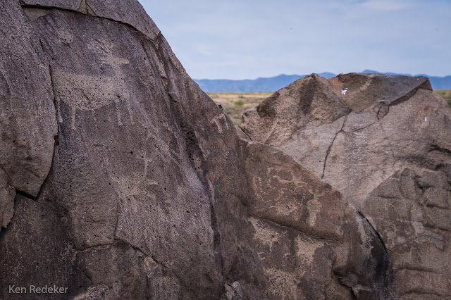
Agua Fria National Monument - Arizona
I spent two days exploring the Richinbar Mine ruins, Hohokam ruins, and
petroglyphs in the Agua Fria National Monument. The first day I went in
the evening, and the second day in the morning.


 |
| Richinbar Mine |


 |
| The Richinbar Mine |
 |
| Hohokam Ruins |
Thursday, April 23, 2020
Horton Creek - Tonto National Forest
This is a beautiful perennial creek just below the Mogollon Rim. I
followed Horton Creek Trail, to the Highline Trail, and returned on the
Derrick Trail for a 9.5 mile loop hike. The Highline Trail was the most difficult section.


 |
| The Highline Trail |
Wednesday, April 22, 2020
Barnhardt Road Campsite - Rye, Arizona
This is beautiful dispersed camping at 3,060 feet elevation near the Mazatzal Mountains. I had left Phoenix to escape the 90 degree desert heat and head to the Horton Creek Trail along the Mogollon Rim. Nights are peaceful here, and my OCD fades to quiet background noise. I always enjoy camping here on my way to the rim country. My car is my home, and the wilderness is my palace.


Thursday, April 16, 2020
Tucson Mountain Park - Tucson, Arizona
I hiked the Starr Pass Trail, Yetman Trail, and Bowen Trail, for a 6.4 mile loop.


 |
| The Painted Cave |
Wednesday, April 15, 2020
Golden Gate Mountain - Tucson Mountain Park
This was a short and difficult 2.6 mile out and back trail with 1,345 feet of elevation gain. I was the only person on this trail. It is part of the Tucson Mountain Range. Golden Gate Mountain has a height of 4,288 feet, and is the 3,950th highest peak in Arizona.


 |
| Crested Saguaro |
 |
| Crested Saguaro |

 |
| My black Honda CRV in the parking lot. |
 |
| On the summit |
 |
| Me on the summit. |


Thursday, April 9, 2020
Saguaro National Park West - Tucson, Arizona
I hiked the Hugh Norris, Sendero Esperanza, and Dobie Wash Trails, creating a 6.4 mile loop.
 |
| Hugh Norris Trail |
Wednesday, April 8, 2020
Gilbert Ray Campground - Tucson, Arizona
Gilbert Ray Campground is located in the Tucson Mountain Park, 13 miles west of Tucson. It has a 130 RV sites and 5 tent sites. I always enjoy staying here during the off season, and even a couple times in the summer under the scorching heat of the desert sun. It's peaceful in the summer.


 |
| Golden Gate Mountain |

Tucson Mountain Park - Tucson, Arizona
The 20,000 acre Tucson Mountain Park has approximately 62 miles of non-motorized shared-use trials.


Friday, April 3, 2020
Chiricahua National Monument - Arizona
Chiricahua National Monument is located in the Chiricahua Mountains of southeastern Arizona. A few days after the Shelter at Home order was declared by the governor for COVID-19, I headed here hoping that few people were in this isolated park. When I arrived at the trailhead was happy to see only one parked in the lot. I hiked the 8mile Big Loop which begins at Echo Canyon trailhead, then connects to Rhyolite Canyon, then Sarah Deming trail, to the Heart of Rocks Loop, to Mushroom Rock, and end via Ed Riggs trail to complete the loop.


Subscribe to:
Posts (Atom)