Wednesday, October 28, 2020

Bighorn Peak - Bighorn Mountains Wilderness, Arizona

Bighorn Peak is a spectacular desert landmark west of Tonopah, Arizona, and can be easily spotted from 30 miles away when traveling Interstate 10; the peak is located about 4 miles north of the Interstate. Bighorn Peak is the highest mountain in the Bighorn Mountains with an elevation of 3,482 feet, and a prominence of 1,400 feet. This wilderness does not have any roads or trails, but the summit can be attained by following a class 3 route from the south. According to the summit register only 6 parties have visited the summit this year, and the last time was in May. The mountains are surrounded by desert plains.

This was the hardest hike that I have done in Arizona, mostly because of all the Teddy Bear Cholla, but also the steepness, and class 3 rock climbing. The mountain was intimidating as I hiked 2.3 miles across the desert plains toward the southern ridge. It was a thrilling accomplishment to stand on the summit after a hard 4 hour ascent. I even forgot I had OCD.

Bighorn Peak

Looking back at my route.

Bighorn Peak

Bighorn Peak

Bighorn Peak

Looking back at my route.

The summit.

Me on the summit.

Looking west from the summit.

Looking east from the summit.

Looking down at my route.

Looking east from the summit.

Looking south from the summit.

Looking east from the summit.

Looking west from the summit.

The summit block that I climbed.

Looking down at my route.


Bighorn Peak

Bighorn Peak

Bighorn Peak

Bighorn Peak and mining ruins.

My route from the canal.


Saturday, October 24, 2020

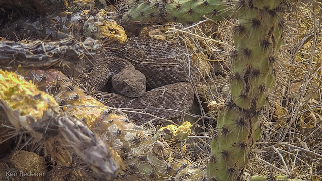
Western Diamondback Rattlesnake - Phoenix Sonoran Preserve

I was out hiking with my friend Tom, and we saw the rattlesnake crossing the trail, and then hide among the cactus. It's always exciting to see a rattlesnake. I took the photo with my phone and zoomed in.


Wednesday, October 21, 2020

Palomino Mountain - Superstition Mountains

I hiked 10.3 miles round trip out to Palomino Mountain in the Superstitions. Most of the route was along the Dutchman Trail #104. At the junction of Black Mesa Trail, and 4 miles later, I left the trail and headed to Palomino Mountain. It took me 7.5 hours. The summit is 2,907 feet, and the top of Palomino Mountain forms three vertical fins or spines that run north-south.

I've become addicted to hiking and climbing mountains. It makes me feel good, and most importantly it nearly eliminates my OCD and depression. When I stand upon a summit after a difficult ascent I have that thrill and sense of accomplishment. I just had 25 years of sobriety, and hiking beats alcohol by a long shot.

The Dutchman Trail

Followed the dry creek bed south from the Dutchman Trail.

This is called The Fortress that I passed through.

Looking back at my route.

Looking back at my route.

Aylor's Arch

Aylor's Arch

Looking back at my route.

Me on the summit.

On the mountain.

The high point that I climbed up.

Aylor's Arch

Aylor's Arch


Aylor's Arch

I walked out on the spine of rock.

I walked out on the spine of rock.

I stopped here. It's too dangerous to cross the arch.

My feet.


West Boulder Canyon

West Boulder Canyon

West Boulder Canyon

Weaver's Needle

West Boulder Canyon


Coming down the mountain.

Back at the Fortress.

Looking back at my route.

Heading back to the Dutchman Trail.

Palomino Mountain

Weaver's Needle from the Dutchman Trail.