Tuesday, April 27, 2021

McDowell Sonoran Preserve - Scottsdale, AZ

I hiked a 10.4 mile loop at the McDowell Sonoran Preserve. I hiked Tom's Thumb Trail to the East End Trail, and followed that tail to the Windmill Trail, to the Coachwhip Trail, to the Pemberton Trail, and finally to the Boulder Trail and past the Marcus Landslide. It took me 4 hours and 41 minutes to complete the loop.

I had a failed first attempt on Tom's Thumb Trail at 10am. It had rained that morning and the skies began to clear and the sun came out. However, clouds began to gather over the McDowell Mountains. I studied the darkening clouds and decided to start my hike since sunshine was only a mile away. But by the time I was less than a mile into my hike it began to lightly rain. I hoped it would be brief and I continued. At 1.3 miles up the mountains the rain increased and sunshine was miles away. I turned around here and ice pellets began to fall with the rain. After a few minutes I was soaked and cold. I made it back to my car in less than a half hour. I changed my shirt and my hiking pants dried out. At noon the sun came out and I started back up the mountains again. I hiked fast because I wanted to finish before 5pm. But first I hiked to Tom's Thumb which took an hour. Then I headed back to the East End Trail to finish the 10 mile loop.


My 10.4 mile hike.


Sunday, April 18, 2021

Goat Camp Trail / Ford Canyon Trail - White Tank Mountain Regional Park

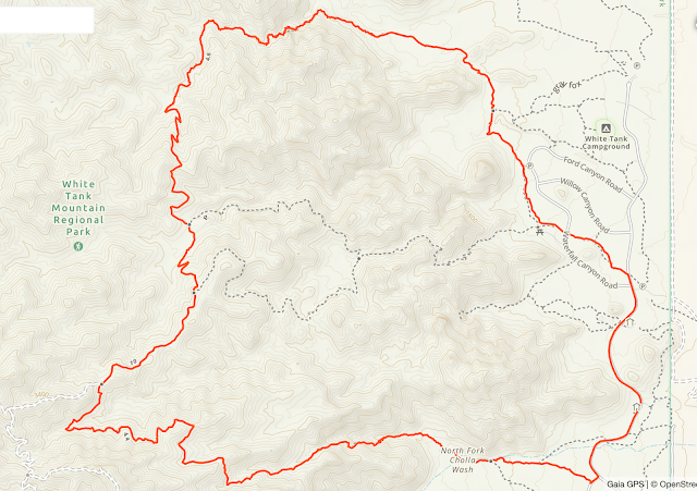
I hiked a 15.2 mile loop trail at White Tank Mountain Regional Park. I started at the Goat Camp Trailhead and exited through the Ford Canyon Trail. Ford Canyon is the most beautiful part of the hike and the most rugged. The Goat Camp Trail is 6.3 miles one-way and begins at parking Area 1 just off Black Canyon Drive. That trail will bring you to the Ford Canyon Trail which will lead you to the Waddell Trail on the desert floor.

I always like a challenge to my hikes. I'm pushing myself to do longer day hikes now. This is my second 15 mile hike that I have done. Fifteen miles is longest I've done in a day so far. My goal is to do a 20 mile day hike. Setting hiking goals helps reduce my OCD, because I focus on something positive.

The name White Tank Mountains was given to this range because there were many bleached out granite tinajas, or water catchments, commonly known as "tanks." This mountain range is on the western periphery of the Phoenix metropolitan area. It was formed through tectonic activities as part of a detachment fault sometime in the mid-Tertiary period, about 30 million years ago.

Goat Camp Trail

Goat Camp Trail


Goat Camp Trail


Goat Camp Trail

Goat Camp Trail

Ford Canyon Trail

Ford Canyon Trail

Ford Canyon Trail

Ford Canyon Trail

Ford Canyon Trail

Ford Canyon Trail

Ford Canyon Trail

Ford Canyon Trail


Northern Black-tailed Rattlesnake

Waddell Trail

My 15.2 mile hike.

Northern Black-tailed Rattlesnake - White Tank Mountain Regional Park

I saw a Black-Tailed Rattlesnake today on my 15.2 mile loop hike at White Tank Mountain Regional Park. I was walking through Ford Canyon and heard the unmistakable rattle, and saw it on the trail. Fortunately the snake didn't want to move, and made some nice poses for me. I sat down on the trail about 6 feet away and was thrilled that snake was cooperating with me. However, it was clearly annoyed by me and my camera.

When I photograph rattlesnakes I forget all about my OCD.

Crotalus molossus (the black-tailed rattlesnake) is found from central Texas west through northern and western Arizona, and south to toward the Mexican Plateau, Mesa Del Sur, and Oaxaca Mexico. Black- tailed rattlesnakes occupy grasslands, deserts, and rocky mountainous areas. They are also found at high altitude pine-oak and boreal forests. The highly hemorrhagic venom is of moderate toxicity, but venom yield from a large snake can be substantial.


Friday, April 16, 2021

Brown's Summit - McDowell Sonoran Preserve

In the late afternoon, I hiked up to the 3,253 foot summit of Brown's Mountain at the McDowell Sonoran Preserve. It's an easy hike that took me only 40 minutes to reach the top with about 650 feet of elevation gain.

The trailhead and Brown's Mountain.

Me on the summit.


My 3.2 mile round trip hike.


Wednesday, April 14, 2021

Miami, Arizona

I've started photographing old mining towns. The history is fascinating. This is Miami, Arizona. Silver mining spurred European settlement in the Miami region in the late 1860s, and in 1911 the Inspiration Copper Mine opened. It currently produces copper and molybdenum and is now called the Miami Mine.


This was a school built in 1923. It was listed in the National Register of Historic Places on January 4, 2001. Now it is the Bullion Plaza Cultural Center and Museum. I visited the museum and it has an interesting collection of artifacts form the Globe-Miami-San Carlos region. Permanent exhibits include the Mining Heritage Collection, Minerals and Gems, Mexican Cultural Exhibit, and Slavic Cultural Exhibit. The museum is free, and definitely worth the stop if you are in the area.


This is the historic Traveler's Hotel built in 1918. One of the first hotels in Miami. 


Tuesday, April 13, 2021

Superior, Arizona

Superior was founded as a mining town for the Silver Queen and the later Magma mines. After 71 years of production, the Magma mine closed in August 1982 due to high operating costs and declining copper prices. Operations resumed in September 1990, but the mine closed again on June 28, 1996. 

Apache Leap From Main Street.

Apache Leap from Main Street.

Main Street

Mural by artist Brent Fiasco on the old American Legion building at 32 N Kellner.

This was Dahling's Grocery Store built in 1912 at 71 Main Street.

Griffee's Market was built in 1912 at 79 Main Street.


Main Street and Picketpost Mountain.


Picketpost Mountain - Superior, AZ

This was my second hike up Picketpost Mountain to the 4,355 foot summit. It had been so enjoyable and challenging I wanted to do it again. The 2.3 mile hike to the summit took me 2 hours and 36 minutes. The round trip hike has 2,070 feet of elevation gain on a confusing social trail.

The top is a fairly large mesa with a few false peaks. The mountain is composed entirely of volcanic rocks, which include rhyolitic lava, tuff, and lava flows of quartz latite composition.


Climbing up the Quartz Latite lava flow.

Looking back at my route.


My route.